While some groundwater systems posing a flood risk are relatively well understood, there has been limited hydrogeological knowledge on the majority of Irish karst groundwater flow systems. Hydrometric data is a crucial component to addressing this knowledge gap and to develop an understanding of these complex groundwater flow systems. Thus a primary objective of our work is to establish a monitoring network to provide key baseline data for flood risk management applications.
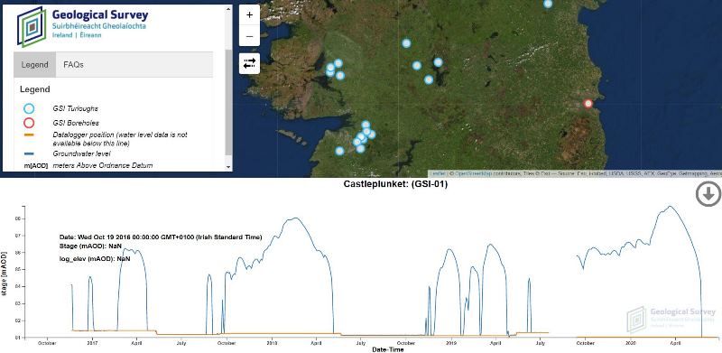
Installation of monitoring infrastructure commenced in October 2016. Over 60 exploratory monitoring stations were installed in counties Galway, Clare, Mayo, Roscommon, Longford and Westmeath. The installation of permanent monitoring stations began in summer 2017 and was completed in mid-2019. A subset of 18 sites representative of the spectrum of groundwater flooding conditions were established as permanent telemetered stations providing real-time information on water levels. Data from the telemetry network is available to the public through our Groundwater Level Data Viewer.
For more information on the data collected by our monitoring network, please see our monitoring data sheets which provide summary information regarding their location and monitoring period as well as summary plots of stage, volume, flood area and net flow.
Exploratory network
Installation of the exploratory monitoring equipment commenced in October 2016 and took place over an 18-month period. Custom-built instrument enclosures were used to house the loggers at each site for easy deployment and recovery during flooded conditions. Water levels, temperature, and conductivity (at a select few sites) were recorded on the hour at hourly intervals using Levelloggers, which were placed at or near the deepest point in each turlough basin. Barologgers were installed within each cluster of sites to compensate for atmospheric pressure fluctuation. Data from Levelloggers and Barologgers were downloaded manually approximately every six months, and access to the loggers was performed by foot or by boat, depending on flooding conditions.
Permanent telemetric network
The installation of the telemetered monitoring network began in summer 2017 and completed in 2019, with a subset of 18 sites representative of the spectrum of groundwater flooding conditions providing real-time information on groundwater flood conditions. The telemetered sites were selected based on hydrological regime and statistical analysis, historic data, flood risk and receptor density, ecological value, and geographical distribution.
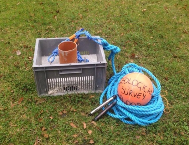
A heavy duty precast concrete box was designed and built for the telemetric monitoring sites. The hollow box was designed with holes to allow water to freely circulate with a logger housed inside recording depth and temperature hourly using a data logger. The data are transmitted through an optical reader to a modem housed within a waterproof enclosure via a direct read cable buried underground.

