Geological mapping is the process of a geologist physically going out into the field and recording geological information from the rocks that outcrop at the surface. Information the geologist looks for will include: boundaries between different rock types and structures e.g. fault-lines and evidence of the rocks undergoing deformation. Mapping is not exclusive to mineral exploration and is an extremely important step in many investigations, as understanding the nature of the underlying rocks in an area is the foundation of all geologically related studies. When conducting mapping as an early stage of mineral exploration, the geologist will be keeping an eye out for ore minerals, evidence of metal-rich fluids passing through the rock, and recording mineralised veins and their distribution. Depending on the scale and extent of the mapping, it may take a team of geologists anywhere from several days to several months to complete.
When mapping as part of mineral exploration, prospecting is accompanied, and both activities go hand-in-hand. It is the process of collecting rock specimens from the field, usually taken across a mineralised location to get a representation of how the metal concentration varies across the potential ore zone. For example, mineralisation may be confined to thin vein/lode bodies, or the metals of interest may have also leaked into the surrounding rock. No chemical analysis is undertaken in the field, as the geologist will take a small sample (< 2kg) broken-off with a hand-held rock hammer, which can be sent to the lab for subsequent analysis.
- Portable X-ray Fluorescence
Depending on the budget of the company conducting the work (this equipment is usually > $20,000), a pXRF instrument may be taken into the field for a mapping-prospecting campaign. XRF stands for X-ray fluorescence, meaning an X-ray is shot from the tool to interact with the test surface, which will then bounce back a second x-ray wave (fluorescence) of a measurable energy – which will be specific to each element on the periodic table. Therefore this allows a quick, rough chemical study in the field which is why it is useful in mineral exploration when looking for metals of interest. The "p" simply stands for portable, meaning it is a hand-held tool operated by the geologist, who will be trained to ensure there is no danger to anyone or livestock.
The instrument itself is equipped with several safety mechanisms such as immediately turning off if a surface is not detected in front of the scanning window when being operated. The scanning window itself is several mm in diameter height and width and the X-rays it shoots out penetrate a distance of several cm before thinning out at length. This means only the material directly in front of the instrument receives any radiation, minus minimal backscatter out each side. The tool is activated for up to approximately 200s depending on the chosen mode, after which the radiation quickly dissipates leaving the area scanned safe for both people and livestock again.
Although the hand-held version is less accurate than lab-based XRF, it saves on lab costs and is compensated by its practicality of being useable in the field. It is useful for mineral exploration in Ireland, as it still produces reliable results for many sulphide minerals such as copper, lead and zinc, the latter two being extremely important exported commodities for Ireland throughout history and still to this day.
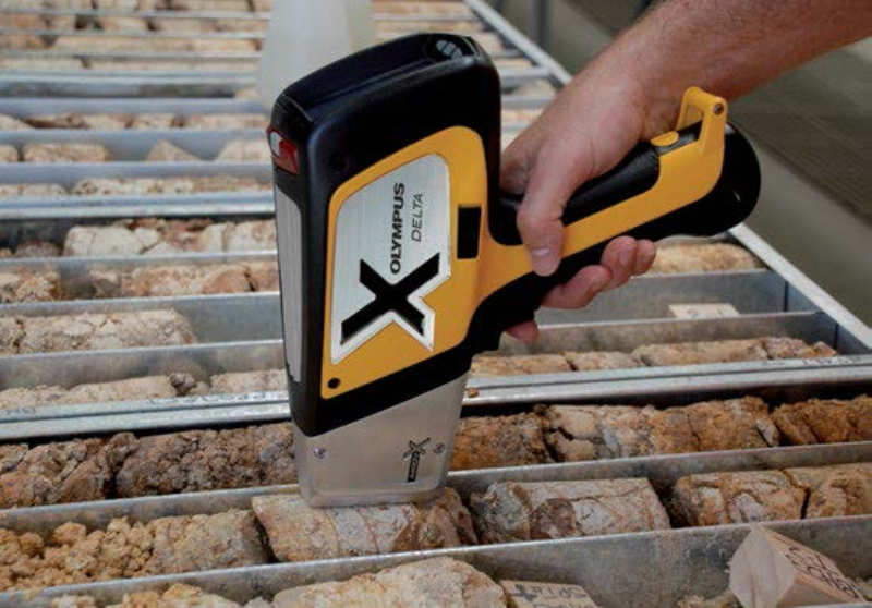 pXRF being used to analyse drill core
Mapping and prospecting are one of the first physical steps taken in a field area by geologists – especially where knowledge of the bedrock geology is limited. This is because it is a relatively inexpensive way to give good information on whether or not to invest in progressing exploration in a licence area any further. This is the nature of all mineral exploration methods, that initially inexpensive methods are used to test whether there is a warrant for further, more advanced exploration, or conversely 'ticking-off' an area as economically uninteresting.
However, it is extremely important to note, that the vast majority of all exploration campaigns – including drilling programmes, will not make it to mine stage. Due to the extremely long planning time and expenditure of mine setup (potentially >10 years and 100s of millions of dollars), very few exploration projects develop into mines. Prospecting and mapping would likely be preceded by desk-study research on the geology and historical mining activity in a licence area, with use of public data – such as made available by the Geological Survey Ireland. This information would then be used to hone-in on specific areas of interest with detailed mapping. This may be followed by and/or done in conjunction with geophysical methods and soil sampling. In areas where rock exposure is limited (much of Ireland's countryside), soil sampling is a vital alternative.