The Intergovernmental Panel on Climate Change (IPCC) published a Special Report on the Ocean and Cryosphere in a Changing Climate on 25 September 2019 showing that we are heading for a worst case scenario of global mean sea level when compared with previous IPCC report (likely ranges are now 1.1m by 2100 under RCP 8.5).
Recent work by Dr Silvia Caloca at Geological Survey Ireland shows how these expected changes could affect the Dublin coastline. The work is part of a project to map the relative susceptibility of the Irish coast to adverse impacts of sea-level rise through the use of a Coastal Vulnerability Index (CVI) and is part of Geological Survey Ireland's Climate Action response.
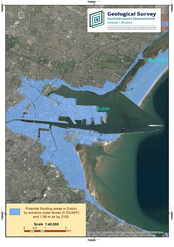 'Potential flooding areas in Dublin from a 0.5 Annual exceedance probability (AEP) event and 1.98m sea-level rise, worst case scenario, projected by 2100'.
The combination of a highly-vulnerable environment identified by means of the CVI (High), and detailed assessment of future impacts of sea-level rise (from extreme water levels events), will help to identify vulnerable areas to sea-level rise. The highest depths of inundation expected in the Dublin area from the 200-year return period event (AEP 0.5) are 5.76m OD by the end of the century. These projections are developed using the current understanding of the high-end, worst case scenario of 1.98 m of sea-level rise (RCP 8.5) (Caloca-Casado, 2018).
Disclaimer: this potential flooding projection 2100 is part of Silvia Caloca's thesis published in 2018 using available data at the time. It is not intended to be used for planning or uses other than support the study of the coastal vulnerability mapping project.