Geophysical data and maps include data from the Tellus project (magnetic, electromagnetic, radiometric data) and other sources (2006 Joint Airborne Geoscience Capability pilot studies and 1979-1981 Hunting Geology and Geophysics Ltd.).
Airborne surveys collect magnetic, radiometric and electromagnetic data. Data are available in merged packages of all the Tellus phases or individually as survey blocks are completed.
| Type | Description |
|---|
Magnetic Data | Airborne geophysical magnetic intensity data (in nT) collected at 10Hz at a nominal survey altitude of 60m and a line spacing of 200m. |
|---|
Radiometric Data | Airborne geophysical Gamma-Ray data (including Total Counts (cps), Potassium (%), equivalent Thorium (ppm) and equivalent Uranium (ppm)) collected at 1Hz at a nominal survey altitude of 60m and a line spacing of 200m. |
|---|
Electromagnetic Data | Airborne geophysical frequency domain electromagnetic data (four-frequencies: 912, 3005, 11962 and 24510 Hz, in-phase and quadrature EM responses and resistivity transforms) collected at 1Hz at a nominal survey altitude of 60m and a line spacing of 200m. |
|---|
| |
|---|
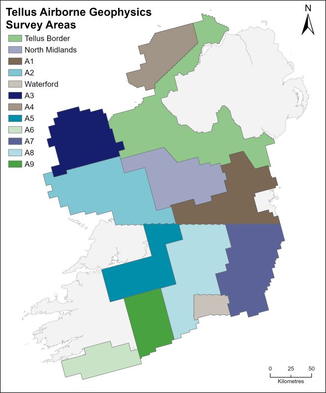 Tellus 2022 Merged areas of Tellus phases
Tellus 2022 A9 block
Tellus 2022 A8 block
Tellus 2019 A7 block
Tellus 2019 A6 block
Tellus 2019 A5 block
Tellus 2018 A4 block
Tellus 2018 A3 block
Tellus 2017 A2 block
Tellus 2016 Waterford
Tellus 2016 A1 block
Tellus 2015 North Midlands
Tellus 2013 Tellus Border
2006 - Joint Airborne Geoscience Capability (JAC) pilot studies (Cavan-Monaghan, Silvermines and Castleisland)
Click map for further detail
Other data
Tellus Caesium 137 2022 Merged areas of Tellus phases
Minerals Prospectivity Mapping (MPM) Project
1979-1981 Hunting Geology and Geophysics Ltd (Central Ireland)
Tellus 2022: Merged areas of Tellus phases
| Data | Access |
|---|
 | Merged areas of all Tellus phases to date, including Tellus Border, Tellus North Midlands, blocks A1, A2, A3, A4, A5, A7, A8, A9 and Waterford Tellus Merge 2022 geophysical technical report (7 MB) Tellus Merge 2022 data release notes |
|---|
| Magnetic data | Tellus magnetic merged data XYZ (854 MB)
Tellus magnetic merged grd, tiff and gxf (843 MB) |
|---|
| Radiometric data | Tellus radiometric merged data XYZ (142 MB)
Tellus radiometric merged grd, tiff and gxf (1.12 GB) |
|---|
| Electromagnetic data | Tellus electromagnetic 2F merged data XYZ (966 MB)
Tellus electromagnetic 2F merged grd, tiff and gxf (530 MB) Tellus electromagnetic 4F merged data XYZ (1.10 GB)
Tellus electromagnetic 4F merged grd, tiff and gxf (771 MB)
|
|---|
| Map Viewer | link to online viewer (select either magnetic, radiometric or electromagnetic tab) |
|---|
| |
|---|
Tellus 2022: A8 block (South-central Ireland)
Tellus 2019: A7 block (SE Ireland)
Tellus 2017: A2 block (Co Galway, including parts of Mayo, Tipperary and Offaly)
Tellus 2016: Waterford (Waterford, parts of southern Tipperary and Kilkenny)
Tellus 2016: A1 block (Meath, Kildare, Offaly, rural Dublin and parts of Laois, Wicklow)
Tellus 2015: North Midlands (Roscommon, Longford, Westmeath)
Tellus 2013: Tellus Border (Donegal, Sligo, Leitrim, Cavan, Monaghan, Louth)
| Data | Access |
|---|
| Merged areas of all Tellus phases to date, including Tellus Border, Tellus North Midlands, blocks A1, A2, A3, A4, A5, A7, A8, A9 and Waterford Tellus Caesium 137 Merge 2022 geophysical technical report Tellus Caesium 137 Merge 2022 data release notes |
|---|
| Caesium 137 Data | Tellus Caesium 137 merged data XYZ (89 MB)
Tellus Caesium 137 merged data grd, tiff and gxf (200 MB) |
|---|
| | |
|---|
Northwest Midlands geophysical lineaments