Radon research
Radon is a radioactive element which occurs naturally in earth materials. Exposure to high concentrations of radon is known to increase the risk of lung cancer. Accurate mapping of its occurrence can help identify households potentially at risk from exposure to radon and assist with highlighting high radon areas for future development. In Ireland, the radon risk map is produced from indoor radon measurements by the Environmental Protection Agency (EPA) . In areas where few measurements exist there may be difficulty in determining radon risks. Geological Survey Ireland is working with the EPA to understand and predict natural sources of radon in rocks, soils and waters nationwide, as part of the National Radon Control Strategy.
Geological Survey Ireland’s Radon Working Group (consisting of geochemistry, geophysics and groundwater experts) is undertaking in-house projects and research partnerships in order to research the complex relationship between radon and geology including sources and transport pathways. Tellus airborne geophysical data and soil geochemistry data along with bedrock, soil and aquifer data provide rich datasets to explore the occurrence and transport of radon in earth materials. Research partners Trinity College Dublin have been undertaking research on radon hazard prediction through an Enterprise Partnership Scheme (financed by the Irish Research Council and Geological Survey Ireland, 2015) and through a Geological Survey Ireland short call research grant (2017), described below.
Enterprise Partnership Scheme fellowship (2015-2017): Radon monitoring and hazard prediction in Ireland
A new high spatial resolution radon risk map of Ireland was developed in this project, based on a combination of indoor radon measurements collated by the Environmental Protection Agency (n=31,910) and relevant geological information (i.e. bedrock geology, subsoil geology, soil permeability and aquifer type). The population affected by radon concentrations above the EPA reference level of 200 Bq m-3 is estimated at ca. 460k (about 10% of the total population).
An average indoor radon concentration by Electoral Division (3,409 EDs) was also calculated, ranging from 21 to 338 Bq m-3. Based on these calculations and the population density in Ireland, it is estimated that of the approximately 2,300 lung cancer cases currently diagnosed in Ireland annually, about 280 may be linked to radon exposure. The results provide a high spatial resolution utility which permit customised radon-awareness information to be targeted at specific geographic areas.
The Tellus airborne geological mapping survey data (i.e. Uranium - eU) and soil properties (i.e. porosity, density, and radon emanation factor) was also used to help develop a method to predict the soil-gas radon concentrations. Radon Potential was then estimated, taking into account subsoil permeability. Selected test sites were further studied using in-situ soil-gas radon and permeability measurements in order to validate the model, and better understand factors affecting production, transport and accumulation of radon in the natural/built environment. It was found that soil-gas measurements were highly variable; however these may be refined by in-situ soil permeability testing and may have value for evaluating radon risk on a localised scale where other data is not available. Findings are published in the following open-access papers.
An All-Ireland Geogenic Indoor Radon Map
Investigator: Dr Quentin Crowley, Trinity College Dublin
Funder: Geological Survey Ireland Short Call 2017
Radon is a naturally occurring radioactive gas, which can accumulate indoors and result in an elevated risk of developing lung cancer. Globally, radon exposure is the second highest cause of lung cancer, resulting in tens of thousands deaths annually. Ireland has some of the highest levels of radon in Europe and eighth highest of 29 OECD countries.
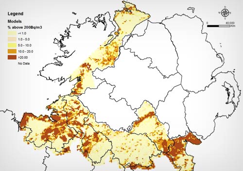
The EU Council Directive 2013/59/EURATOM defines strategies to reduce exposure to ionising radiation. The directive must be transposed into national legislation by 2018, where it is expressly mentioned that radon exposure has to be addressed in National Action Plans. Predictive models of indoor radon exist for both the Republic of Ireland and Northern Ireland, but these have not used a common approach. This proposal will utilise datasets currently held by the GSI, GSNI, the EPA and EA and invigorate north-south research collaboration. This development / demonstration project will almost double the number of georeferenced indoor radon measurements available in the Republic of Ireland and integrate these with the NI dataset, thereby providing over 86,000 measurements. Novel logistic regression methodologies will be utilised, resulting in the first all-Ireland geogenic indoor radon risk map, informing local councils and government agencies on radon prone areas.
Download report
Application of airborne radiometric surveys for large-scale geogenic radon potential classification 
Javier Elío1,2*, Quentin Crowley1, Ray Scanlon3, Jim Hodgson3, Stephanie Long4, Mark Cooper5 and Vincent Gallagher3
1Centre for the Environment, Trinity College, Dublin, Ireland; 2Department of Planning, Aalborg University Copenhagen, Copenhagen, Denmark; 3Geological Survey, Dublin, Ireland; 4Environmental Protection Agency of Ireland, Dublin, Ireland; 5Geological Survey of Northern Ireland, Belfast, Northern Ireland
Abstract
Background: Indoor radon represents an important health issue to the general population. Therefore, accurate radon risk maps help public authorities to prioritise areas where mitigation actions should be implemented. As the main source of indoor radon is the soil where the building is constructed, maps derived from geogenic factors ([e.g. geogenic radon potential [GRP]) are viewed as valuable tools for radon mapping.
Objectives: A novel indirect method for estimating the GRP at national/regional level is presented and evaluated in this article.
Design: We calculate the radon risk solely based on the radon concentration in the soil and on the subsoil permeability. The soil gas radon concentration was estimated using airborne gamma-ray spectrometry (i.e. equivalent uranium [eU]), assuming a secular equilibrium between eU and radium (226Ra). The subsoil permeability was estimated based on groundwater subsoil permeability and superficial geology (i.e. quaternary geology) by assigning a permeability category to each soil type (i.e. low, moderate or high). Soil gas predictions were compared with in situ radon measurements for representative areas, and the resulting GRP map was validated with independent indoor radon data.
Results: There was good agreement between soil gas radon predictions and in situ measurements, and the resultant GRP map identifies potential radon risk areas. Our model shows that the probability of having an indoor radon concentration higher than the Irish reference level (200 Bq m-3) increases from c. 6% (5.2% – 7.1%) for an area classified as Low risk, to c. 9.7% (9.1% – 10.5%) for Moderate-Low risk areas, c. 14% (13.4% – 15.3%) for Moderate-High risk areas and c. 26% (24.5% – 28.6%) for High risk areas.
Conclusions: The method proposed here is a potential alternative approach for radon mapping when airborne radiometric data (i.e. eU) are available.
Link to the publication page.