Remapping the Moffat Shale Group using Tellus geophysics
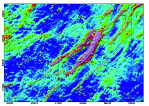
The Moffat Shale Group is a deep marine mudstone sequence that forms the base of successive thrust slices of metasedimentary rocks in the Longford – Down geological terrane. Detailed mapping of the distribution of the shales is relevant to mineral prospectivity and understanding the closure history of Iapetus at the Laurentian margin. Moffat shale horizons produce a strong conductivity signal in the Tellus and Tellus Border airborne geophysical survey data. Recent work in the Geological Survey of Ireland combined interpretation of the airborne electromagnetic data with re-examination of 19th century 6″ field sheets and core drilling to re-map the Moffat shales in Co. Monaghan. Drilling of a blind anomaly proved the efficacy of the method. The re-mapping has identified a revised distribution of Moffat shales and therefore of the tract-bounding faults, including identifying a new structural panel.
Unravelling ice sheet history using Tellus soil geochemical data
Investigator(s): Dr Paul Dunlop, Innovation Ulster Ltd; Dr Michael Dempster, University of Ulster.
Funder: EU INTERREG IVA -funded Tellus Border project
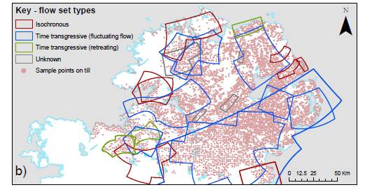
Ice sheets are an integral part of the global climate system and investigating their behaviour provides crucial information on how they respond to and drive climatic changes. Past and palaeo-ice sheets have left a rich geological record, which can be used to reconstruct former ice sheet events through glacial/deglacial cycles. The north of Ireland has a diverse geology and a complex glacial history. This study undertook the first regional-scale investigation of geochemistry in the northern sector of the Irish Ice Sheet, in order to inform understanding of regional ice flow patterns. Principal components analysis showed a strong geochemical link between till and local bedrock, with rapid geochemical changes observed across lithological boundaries, indicating that transport distances of subglacial material were low. The work concluded that the majority of till deposits in the survey area have been locally derived, meaning that the rate of subglacial transport in this sector of the Irish Ice Sheet was low and that there were low rates of evacuation of subglacial debris to the ice margins.
 Download poster
Download report
Peer reviewed publication
An All-Ireland quaternary map
Investigator: Dr Mark Cooper, Geological Survey of Northern Ireland
Funder: Geological Survey of Ireland Short Call 2015
This project aims to produce an All-Ireland Quaternary map at 1:500,000 scale using data from the Geological Survey of Ireland, the Geological Survey of Northern Ireland and the BRITICE project. These will be available as a seamless digital data set composed of 17 sediment types and 4 geomorphological features.
Download report
Detrital zircon geochronology in the west of Ireland in support of Tellus geophysics interpretations
Investigator: Prof Nancy Riggs, Trinity College Dublin
Funder: Geological Survey Ireland Short Call 2017
Tellus geophysical surveys are providing a wealth of new information about the tectonic amalgamation of Ireland. This proposal requests funds to complement new Tellus data and interpretation with a zircon geochronology program to study successions in Mayo and Connemara.
We present here three research goals, all of which will use interpreted Tellus data:
- a test of the age and history of a proposed suture between Ordovician Clew Bay Complex ophiolitic rocks and Dalradian supracrustal rocks;
- a test of the provenance of rocks in the South Connemara Group, which has implications for sites of gold mineralisation;
- a test of terrane amalgamation through understanding Silurian rocks that cover tectonic sutures.
The greatest impacts of our work will be in scientific discoveries, demonstration of methods that add value to collection and interpretation of Tellus geophysical data, and through training a TCD undergraduate in research methods.
Download report
Geophysical remote sensing of subsurface properties for sustainable agricultural management
Investigator: Dr Eve Daly, NUI Galway
Funder: Geological Survey Ireland Short Call 2017
This proof of concept project will start by integrating airborne and ground geophysics with remote
sensing to access surface and subsurface permeability variations over a Teagasc Agricultural Catchment which is covered by existing Tellus data, in the context of agricultural management. The project will explore the best methods to then upscale to Water Framework Directive scale catchments and the tools and international collaborations needed to build a functional land
management tool for the sustainable management of agricultural intensification envisioned in Food Harvest 2020 and Food Wise 2025.
This multidisciplinary proposal is aligned with three Short Call research themes:
- Geophysics
- Groundwater Resources and Protection
- Quaternary Geology of Ireland
The project will develop a new research programme covering hydrogeophysics, soil science and catchment science building on expertise gained in the 2007 Griffith Geoscience Award to NUIG and develop the recent collaborations between Teagasc (Ireland's Agricultural and food development authority) and NUIG and the Geological Survey of Ireland.
Download report