How "Green" is our Air? Epiphytes as proxies for air quality in the Tellus Border region
Investigator(s): Howard Fox/National Botanic Gardens
Funder: EU INTERREG IVA -funded Tellus Border project
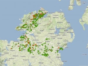
The epiphytic organisms include lichens, fungi, bryophytes (mosses and liverworts) and algae. The lichens, in particular, are sensitive to anthropogenic pollution of air and water (in mists and precipitation). This study undertook biomonitoring of eiphytes growing on 700 twig samples, collected as ‘by-catch’ during the Tellus Border geochemical survey, to assess the environmental health of rural air quality, i.e. eutrophication, in the border region of Ireland. A distinctive “aerial green algal bloom” was observed on 75% of the vegetation samples examined. There is evidence that pollution-sensitive epiphyte species in the Tellus Border region suffer from excessive deposition of airborne nitrogen leading to the success of pollution-tolerant species at the expense of pollution-sensitive species.
Download poster
Download paper
Mining contamination impacts on steam sediment in Northern lreland
Investigator(s): British Geological Survey
Funder: EU INTERREG IVA -funded Tellus Border project
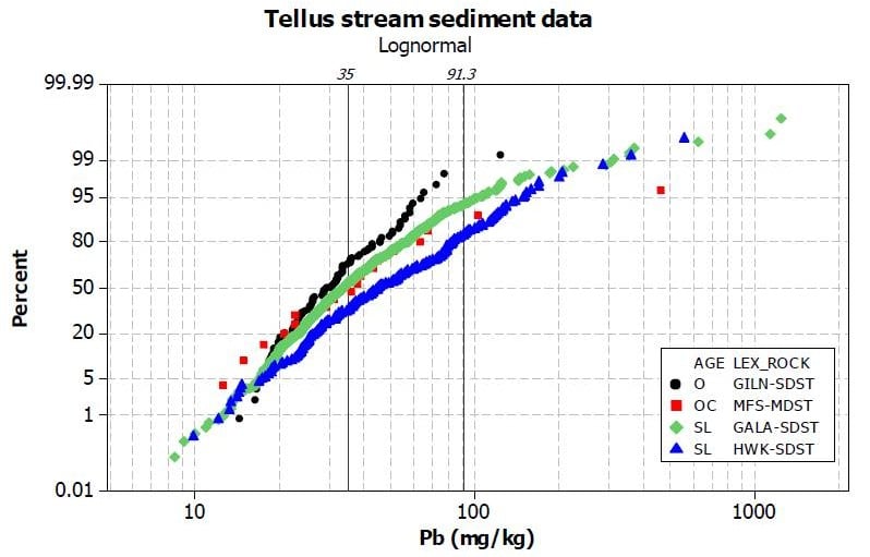
Information on the baseline conditions of water catchments prior to mining is needed to better understand what restoration goals are achievable in mining impacted catchments. The Tellus geochemical baseline data provide a reference point against which changes can be measured and can be used both by industry and regulators in future mine applications. In this project pre-mining baseline sediment concentrations were derived using Tellus stream sediment data for a mineralised area associated with the Ordovician-Silurian rocks in southern Co. Armagh, Northern Ireland. Using exporatory data analysis, lead, zinc, chromium, nickel and arsenic data were examined using exploratory data analysis techniques, revealing several data populations for each element relating to natural geochemical variation and mineral extraction impacts across geological units.
Download poster
Download report
Investigator(s): Queen’s University Belfast
Funder: EU INTERREG IVA -funded Tellus Border project
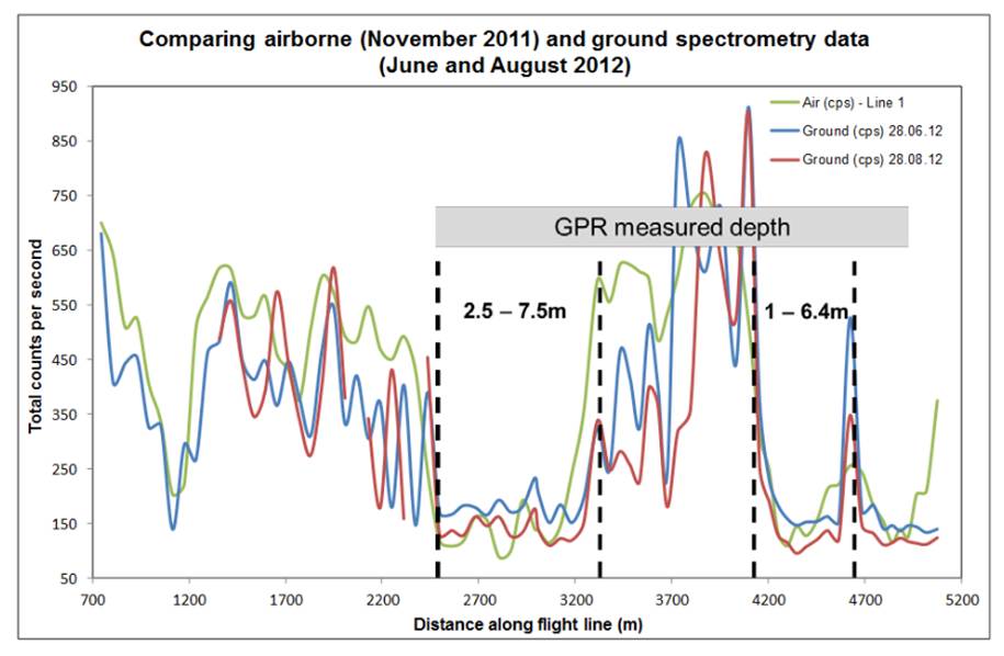
It has become increasingly important to measure and model soil carbon stores and changes in peat stocks to facilitate the management of carbon changes over time. This two-year postdoctoral reseach project evaluated the use of Tellus airborne geophysical (radiometric) data to estimate peat thickness, based on the principle that the radiometric signal is attenuated or reduced by the high water content in peat. Airborne geophysical measurements were validated with ground peat depth measurements combined with non-invasive ground-based geophysical surveys at two bogs in Northern Ireland. Geospatial statistics techniques examined changes in peat stocks over time. The work presents the possibility that by integrating remotely sensed data with ground geophysics, the need is reduced for invasive and damaging on-site peat depth measurements.
Download poster
Download report
Peer reviewed publication
Assessing marine and anthropogenic influences on the terrestrial biosphere strontium isotope budget
Investigator: Dr Quentin Crowley, Trinity College Dublin
Funder: Geological Survey of Ireland Short Call 2015
This project aims to characterise modifications of soil chemistry due to marine and agriculturally-derived influxes. Tellus geochemical data will be used to identify deviations from expected trends. Additional samples will be selected for strontium isotope analysis, resulting in a more accurate estimate of geochemical fluxes in the contemporary Irish biosphere.
Download report
Development of integrated protocols for the rapid mapping and assessment of metal contamination in intertidal and supratidal environments
Investigator: Dr Helen Roe, Queen's University Belfast
Funder: Geological Survey of Ireland Short Call 2015
This project aims to develop new methodologies to aid in the rapid mapping and assessment of metal contaminants in intertidal and supratidal environments. The study will employ multidisciplinary approaches that will utilise ITRAX-core scanning, intertidal foraminifera, a group of protozoans that are sensitive to metal contamination, and Tellus geochemistry data.
Download report
Building on Tellus: Preliminary Investigations into Geochemical Processes occurring in Connemara Blanket Bogs
Investigator: Prof Peter Croot, NUI Galway
Funder: Geological Survey Ireland Short Call 2017
The blanket bogs of Ireland are amongst the most celebrated land features of the country, appearing in prose, poem, photo and song and resonate strongly in the social and cultural heritage of the land. Blanket bog landscapes are biologically diverse and are increasingly becoming valued for eco-tourism but their sustainable use is a balance between traditional practices (i.e. turf cutting), industrial use (i.e. wind farms) and the ecosystem services they provide. The Irish government has recognised the importance of the sustainable use of Peatlands through the publication in 2015 of the National Peatlands strategy. However a critical knowledge gap exists regarding the (bio)geochemistry of these peatlands. To address this issue, we propose a preliminary study into the (bio)geochemistry of the Connemara blanket bogs building on the recent Tellus survey of this region to develop a framework for studying the (bio)geochemistry of these ecosystems. In this context we will focus on 3 aspects of blanket bog geochemistry: (i) Redox cycling of coloured and fluorescence dissolved organic matter (CDOM/FDOM) (ii) Role of organic matter and redox in the distribution of pH sensitive metals (e.g. Fe, Al, Ti, U) in peatlands. (iii) 222Rn release from blanket bogs.
Download report
A new digital database of Ireland's electromagnetic fields to mitigate against Space Weather
Investigator: Dr Joan Campanya, Trinity College Dublin
Funder: Geological Survey Ireland Short Call 2017
As society becomes increasingly dependent on renewable energy and electricity, reliability of electricity supply and electric infrastructure is key to national development. One challenge associated with becoming more dependent on electricity is the potentially catastrophic effects of Space Weather, or solar storms, which can severely damage electric infrastructure. There is a pressing need to accurately model the electromagnetic (EM) fields caused by large solar storms which interact with the Earth's subsurface geology and form geomagnetically induced currents (GICs) that cause damage to ground-based infrastructures. We propose to collect new long-period EM data to assist in a better understanding and modelling of Ireland's EM fields. We will create a digital database containing key information for modelling and monitoring EM fields caused by solar storms, such as:
- EM time series
- Tensor relationships between the electric and magnetic fields
- a three-dimensional electrical resistivity model of Ireland's lithosphere.
The database will be made publically available in EPOS and GSI, and will complement current research projects in TCD, mitigating against effects of solar storms in the Irish power network, and DIAS, understanding geological and physical processes of Ireland's lithosphere.
Download report