Coastal Vulnerability Index (CVI) mapping to evaluate impacts of sea-level rise
Project description
The vulnerability of the coast is intimately correlated to its characteristics and the intricate physical processes that would affect its evolution. Geological Survey Ireland is undertaking a new coastal vulnerability mapping initiative. Maps produced in this project will provide an insight into the relative susceptibility of the Irish coast to adverse impacts of sea-level rise through the use of a Coastal Vulnerability Index (CVI). This method, based on physical parameters, was adapted to the local context to explore the relationships between drivers, (e.g. sea level rise), geological boundary conditions and the coast's responses.
CVI will offer an easy visual representation of sensitive areas, enabling coastal managers to prioritize or concentrate efforts on adaptation. The main areas of vulnerability will be identified by both CVI and the analysis of individual variables, also called coastal indicators: geomorphology, cliff type, coastline orientation, regional coastal slope, tidal range, significant wave height, relative sea-level rise, and long-term shoreline erosion and accretion rates.
Outputs
The first phase of CVI mapping
mapped coastal areas in Co. Dublin. This mapping also includes several data
layers of the most relevant coastal indicators to allow the user to view both
the coastal vulnerability index (CVI) and the data from which the CVI is
calculated.
Coastal Vulnerability Index (CVI) map showing ranges of vulnerability from very low to very high in Co. Dublin.
Potential flooding areas in Dublin projected by 2100
The combination of a highly-vulnerable environment identified by means of the CVI (High), and detailed assessment of future impacts of sea-level rise (from extreme water levels events), will help to identify vulnerable areas to sea-level rise. The highest depths of inundation expected in the Dublin area from the 200-year return period event (AEP 0.5) are 5.76m OD by the end of the century. These projections are developed using the current understanding of the high-end, worst case scenario of 1.98 m of sea-level rise (RCP 8.5) (Caloca-Casado, 2018). There is uncertainty on the effects of climate change on future storms behaviour and probability of occurrence of extreme events. Latest research (IPCC, 2021) predicts that extreme sea level events that previously occurred once in 100 years, could happen every year by the end of this century.
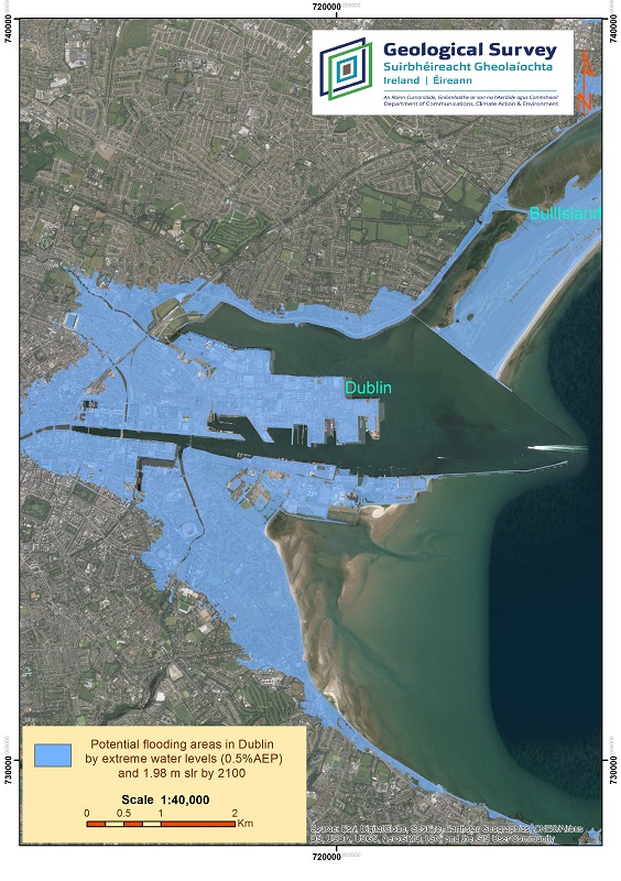 Potential flooding areas in Dublin from a 0.5 Annual exceedance probability (AEP) event and 1.98m sea-level rise, worst case scenario, projected by 2100.
This potential flooding projection 2100 is part of Silvia Caloca's thesis published in 2018 using available data at the time. It is not intended to be used for planning or uses other than support the study of the coastal vulnerability mapping project.