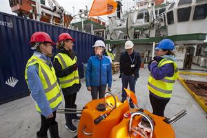
Colleagues at the Dublin Institute for Advanced Studies set sail aboard the RV Celtic Explorer from Cobh harbour this week to deploy 18 ocean bottom seismometers in the NE Atlantic. The equipment is part of the iMARL network, the Insitu Marine Laboratory for Geosystems Research, which can monitor ground vibrations and marine acoustic signals in the deep ocean.
Increasingly we are looking to the marine environment for our resources (energy, transport, food, communications etc.) yet we know little about the interaction of the solid Earth and ocean systems. To fully understand our potential resources, and how best to manage them, we need to improve our knowledge of our dynamic offshore territories.
We also need to better understand potential risks (e.g. to offshore energy and communications infrastructure) in the marine environment and the hazards potentially affecting our coastal communities (flooding/inundation, coastal erosion/migration, submarine collapses etc.)
The equipment will be deployed over the next 3 weeks as part of the
SEA-SEIS project. This project, funded by Science Foundation Ireland, Geological Survey Ireland and the Marine Institute, is led by Prof. Sergei Lebedev from the Dublin Institute for Advanced Studies (DIAS), and will measure movement at the floor of the Atlantic Ocean, hundreds of kilometres off the coast of Ireland (see map above, map source: DIAS). For more about the project see the
SEA-SEIS video.
The seismometers will be in place for the next 20 months where they will collect data about the nature and history of the vast ocean floor off Ireland's West Coast.
Professor Chris Bean, Senior Professor of Geophysics and Director of the DIAS School of Cosmic Physics, said: “The geological evolution of Ireland’s offshore territory is fascinating, but there is still so much of it to be explored. As originally discovered by DIAS and collaborators in the late 1980’s, and subsequently confirmed and studied in detail by the Marine Institute/Geological Survey Ireland, Ireland has an ocean territory 10 times larger than its terrestrial landmass".
“There are geological, oceanographic, and biological processes that interact on a daily basis in this vast territory but, until now, have been poorly understood due to a lack of observational equipment. For the first time, through the SEA-SEIS project we will be able to make long-term direct observations of the interactions between our oceans and solid Earth in this region.”
Prof. Lebedev, added “Ireland is uniquely suited to this type of deep-sea science, as 90 per cent of the Irish territory is offshore, most of it to the West of Ireland. The ocean-bottom sensors will record the tiny vibrations of the Earth caused by seismic waves, generated by earthquakes and by the ocean waves. As the waves propagate through the Earth’s interior on their way to the seismic stations, they accumulate information on the structure of the Earth that they encounter".
 Using this data, the scientists at DIAS can build a 3D
image of the structure beneath the Earth’s surface. We will discover how the
structure of the tectonic plates varies and what happens beneath these
plates.”
Using this data, the scientists at DIAS can build a 3D
image of the structure beneath the Earth’s surface. We will discover how the
structure of the tectonic plates varies and what happens beneath these
plates.”
Maria Judge (GSI, centre) with DIAS PhD Students Laura Berdi, Janneke de Laat and Clara Gómez Garcia. Photo: DIAS
Schools CompetitionIn the lead up to the launch of the SEA-SEIS project, the scientists at DIAS invited suggestions for names for the seismometers from secondary schools across the country. Each seismometer has a name, proposed by schools from across Ireland,
Through ongoing social media output and ship-to-classroom video links, schools will be able to follow the progress of the RV Celtic Explorer and the deployment of the seismometers, over the next three weeks.