Geological Survey Ireland releases groundwater flooding maps and live turlough data service
- Launch of Geological Survey Ireland Groundwater Flood Mapping and Hydrometric Web Service
- Karst groundwater flooding, or turlough flooding, is a feature of large areas in the midlands and west of Ireland
- Work carried out by Geological Survey Ireland has increased the understanding and data availability for groundwater flooding areas
- The new data products will inform future planning and development in flood-prone areas
The new groundwater flooding maps and data are results of the 2016-2019 GWFlood project which was established in the aftermath of the serious groundwater flooding event of winter 2015/2016. The remit of this project was to advance understanding of karst groundwater flooding in Ireland and address the deficit of data available. To achieve this, Geological Survey Ireland, in collaboration with Trinity College Dublin and the Institute of Technology Carlow, developed a monitoring, mapping and modelling programme to address the knowledge gap regarding karst groundwater systems. The project team worked with local authorities and the OPW to produce flood maps and data products which can be used to inform future flood risk management strategies.
As part of this project, European Space Agency Copernicus Programme Satellite Imagery was used to develop two types of groundwater flood maps. The first, the historic flood map, shows the extent of observed groundwater flood events, and is mainly based on satellite mapping of the 2015/2016 flood event, which in most areas represented the largest groundwater flood event on record. The second, the predictive flood maps, have also been developed for areas of recurrent groundwater flooding (turloughs), with flood levels and extents predicted for a range of annual exceedance probabilities (i.e. return periods).
Outlining the importance of the flood maps, the Minister with responsibility for Geological Survey Ireland, Eamon Ryan T.D., commented: "The effects of climate change are being increasingly seen in Ireland and we need to response to this in scientifically-driven ways. The groundwater flooding that periodically effects large parts of the Midlands and West is a complex issue, but I am encouraged that the work of our Geological Survey is helping to contribute to solutions for vulnerable communities. These new maps will enable local and national authorities to make more scientifically-informed decisions regarding groundwater flood risk management in karst areas."
Koen Verbruggen, Director of Geological Survey Ireland, added: Satellite data has transformed the way we are tackling many geohazards, including now the monitoring of groundwater flooding in Ireland. It provides a practical method to approach a complex problem and represents a step-change in tackling this issue."
The flood maps and their accompanying report, which have already been made available to the OPW, are available here: https://www.gsi.ie/en-ie/programmes-and-projects/groundwater/activities/groundwater-flooding/gwflood-project-2016-2019/Pages/default.aspx
Geological Survey Ireland has also launched its hydrometric data viewer and download service. The viewer, which provides real time hydrometric data from the Survey's growing groundwater monitoring network can now be accessed at https://gwlevel.ie. This data will be of benefit to local and national authorities, researchers and individuals affected by groundwater flooding. It will be available to aid decision making on flood risk management, abstraction, infrastructural development and climate change adaptation.
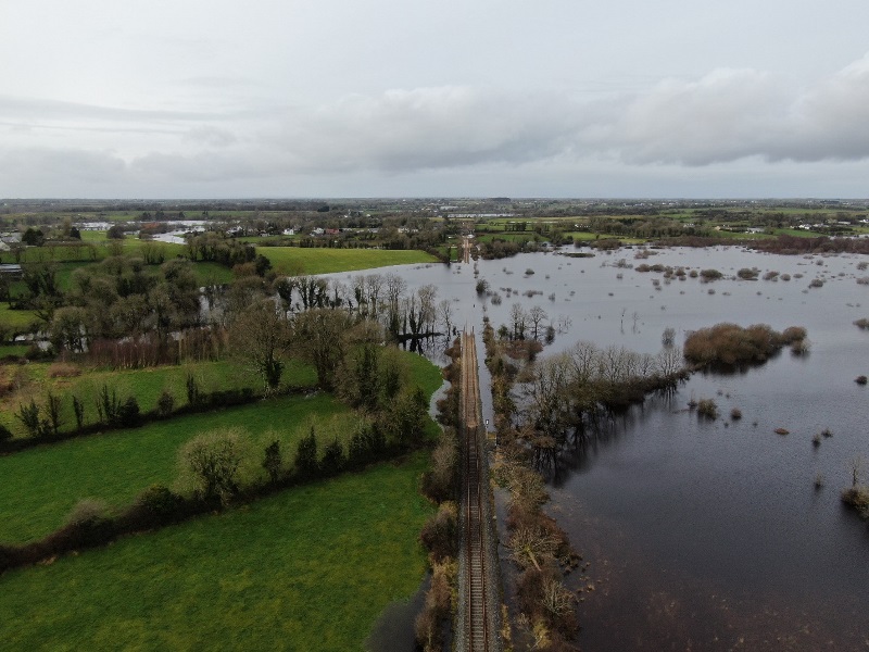 Groundwater along the western railway corridor near Gort, Co Galway, in winter 2020. Photo credit: Galway County Council.
Editors notes:
- Geological Survey Ireland is the National Earth Science organisation and is a division of the Department of Communications, Climate Action and Environment. It is responsible for providing geological advice and information, and for the acquisition of data for this purpose. The Survey produces a range of products including maps, reports and databases and acts as a knowledge centre and project partner in all aspects of Irish geology. www.gsi.ie
- Turloughs are defined as 'Topographic depressions in karst, which are intermittently flooded on an annual cycle via groundwater sources and have substrate and/or ecological communities characteristic of wetlands' (WFD Groundwater Working Group, 2004). They require a moist climate and low lying limestone to occur, and they are virtually unique to Ireland. Over 400 turloughs are known to exist, and due to their unique flora and fauna, many are protected as Priority Habitats and Special Areas of Conservation by the EU Habitats Directive and 'Groundwater dependent terrestrial ecosystems' by the EU Water Framework Directive.
- The word 'turlough' comes from the Irish 'tuar' meaning dry and 'lach' meaning place ('lach' is often misspelled and thought to 'loch' meaning lake).
- A hydrometric data viewer is an interface that provides you with access to water level data. The GWLevel.ie service will provide data from Geological Survey Ireland's growing groundwater monitoring network. It currently consists of data from 18 turloughs and one borehole. Through a newly initiated project, GWClimate, this monitoring network is will be expanded to more locations with particular focus on groundwater bodies which are anticipated to be impacted by climate change.